

Parkland, Coral Springs, and the Canal Grid's Rodent Pressure
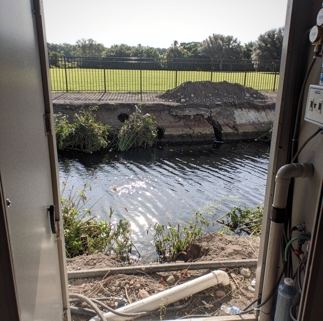
On a single block in Coral Springs or Parkland, one row of houses backs onto open water and the row facing it does not. Canals run through many sections of both cities, behind entire rows of houses that face a street on one side and water on the other, and a street address gives no sign of which side of that split a given lot sits on.
Some properties along that block are tied into the water network, and some are a yard removed from it. Rodent pressure across Parkland and Coral Springs follows that connection, not a municipal boundary and not a street address. What borders the rear of a lot does more to set its baseline than the subdivision it sits in or the standard it was built to.
Coral Springs is built around an extensive engineered canal network, with drainage districts maintaining the waterways that run behind residential blocks. Parkland's water network runs smaller and newer, threaded through master-planned communities rather than laid out ahead of them, but it works the same way: as a connected system, a property either backs onto or does not.
Quick Answer: In Parkland and Coral Springs, a canal network does not uniformly increase rodent pressure across a community. A lot backing onto open water or a preserve edge carries more connected cover than an interior lot on the same street.
The Rear Line and What Borders It
A canal-front lot and the lot directly across the street can share the same square footage and the same construction age, yet still present two different pictures. The canal-front yard backs onto open water with nothing closing off that rear line the way a fence closes the other three sides of most interior lots; whatever cover grows along the bank runs straight into the yard without a barrier interrupting it. The interior lot two doors down, fenced on every side but the front, has cover that dead-ends at each property line instead of running through. That difference in what borders the rear of the lot, not anything about the house itself, is what separates the two.
A Contained Basin against a Continuous Run
A canal and a retention pond both put water at the edge of a yard, and from the street they can look interchangeable. What differs is where each one goes. A canal is a segment of a system that extends beyond the property line in both directions, often for a long, uninterrupted run, connecting one backyard to the next and eventually to a whole stretch of the neighborhood. A retention pond is typically a single, contained basin serving one section of a development, and it ends where the basin ends. A bank works as a route for the reason a bank holds a burrow in the first place, a mechanism covered on its own elsewhere; what changes at neighborhood scale is how far that route reaches once it runs continuous rather than contained.
Where a Golf Course's Water Hazards Extend the Same Network
Parkland and Coral Springs both carry golf course communities threaded through otherwise ordinary subdivisions, and a course adds connected edge of its own. A water hazard bordering a fairway sits inside the same kind of lightly disturbed margin a canal bank offers, and it often runs behind a long stretch of backyards that never touch open canal water at all. A house backing onto a fairway or a hazard carries a connected edge of the same kind, by a different route, even on a street with no visible water in front.
The Preserve Edge and the Unbuilt Parcel
Both cities sit close enough to the Everglades and its buffer lands that much of the western edge of each backs onto something other than another yard: a preserve, a conservation tract, or a parcel not yet built out. That edge behaves differently from a maintained bank. It is not kept to a residential standard; it is not mowed on a schedule tied to an HOA calendar, and it holds cover through stretches of the year a managed yard does not. A lot backing onto that kind of edge carries pressure from ground nobody is actively managing, a different exposure than a canal bank that at least gets cut on some cycle.
Why Two Blocks in the Same Development Read Differently
A single subdivision can wrap around more than one kind of edge at once: canal along one boundary, a retention pond in the middle, a preserve buffer against a fence line entirely apart from either. One street in it backs onto a canal running the length of the block; another backs onto a courtyard and a parking area with no water or preserve edge behind it at all. Reading the development as a single unit overlooks that split, and so does treating its name as a description of what any given lot sits on.
What One Property Changes for a Whole Street
A canal or a preserve edge does not stop at a property line, and neither does what happens on one lot along it. A canal-front yard where the bank has gone unmanaged for a long stretch, overgrown well past what the rest of the street carries, extends usable cover to the neighboring yards on either side, kept clear or not. The same holds in reverse: one well-kept stretch of bank does not close off the water behind it, since an animal working that shoreline can continue past the maintained section to the next yard where cover picks back up. A street facing a canal, a pond, or a preserve functions as one connected unit along that edge, even though each homeowner on it is only responsible for their own portion of the yard.
An unmown preserve buffer or a golf course's water-hazard bank can hide uneven ground and standing water beneath the growth. It is not ground to walk to get a look at what the edge behind a property is carrying.
Frequently Asked Questions
It carries storm sheet flow off both yards toward the nearest canal or pond, which is why it is graded slightly lower than the ground on either side. Two things follow from that grade. The strip holds moisture longer after rain than the yards it separates, and an easement of that kind is generally kept clear so flow is not blocked. What is left is a narrow run of shared, semi-open ground leading from the back of two lots out toward the water, on a line neither owner treats as their own to plant up or close off.
In how far the edge goes. A pond's bank closes on itself: follow it, and it returns to where it started, because the basin serves one section of a development and its perimeter ends on itself. The one place it connects outward is the control structure, the outfall pipe or weir that discharges the basin into the wider drainage system, and that is a single point on the bank rather than the length of it. A canal bank has no perimeter of that kind, which is what puts a canal-front lot on the same edge as blocks its owner never sees.
A continuous line that goes somewhere. The equipment and cart route behind the fairways is a service corridor rather than a feature of any one hole: it links the course's maintenance yard, where machinery and materials are kept, to every part of the property, so it runs the length of the course rather than stopping where a hazard does. It is kept clear for equipment but not mowed to a residential standard; it passes behind a long run of backyards, and it usually falls outside what any single homeowner or association crew maintains.
Often not the homeowner. Drainage districts generally hold a right-of-way along the top of the bank, a strip running the length of the canal that the district keeps access to for dredging, bank repair, and vegetation work. Strips of that kind are generally kept clear of fencing and heavy planting so equipment can get through. The practical effect at the rear of the lot is that the ground closest to the water is on a maintenance cycle the owner does not set and is rarely told about, and whatever cover it carries at any given time reflects that cycle rather than anything the household did.
A gated community's perimeter wall is usually built to a continuous masonry standard along the street frontage and at the entrance, where it controls car and foot traffic, but the stretches running along a canal, a preserve, or an undeveloped parcel at the back of the property are more often a shorter decorative wall, open rail fencing, or no barrier at all. The gate that controls vehicle access does not necessarily close off the water's-edge or preserve-edge perimeter behind the homes that back onto it.
The cover established along that stretch comes off, sometimes for a long run at once, and the bank sits bare until it fills back in. The two jobs leave different ground behind. Dredging pulls material out of the channel, and the spoil is often staged along the top of the bank before it is hauled away, so the bank carries loose piled material for part of the job. Regrading reshapes the slope itself, so what fills back in afterward is growing on a different profile than what was there before. Either way, that section is not the edge it used to be until the cover returns.
Have the rear line of the property read, edge first — you get the connection traced before it turns into activity at the house. Buggify Pest Solutions serves Boca Raton, West Boca, and communities across Palm Beach and northern Broward. Call Tyler: (561) 672-0200.
